Places of Spanish Florida
Spanish Florida can be defined as the broad geographic region within which Spanish colonial settlements and affiliated Native American groups interacted within a multi-ethnic colonial society at least nominally administered as part of the broader Spanish colonial empire between the 16th and 18th centuries. Its geographic extent fluctuated considerably over the 250-year period between 1513 and 1763, and formalized (if mostly theoretical) boundaries were not even established until competing European powers began to encroach on Spanish Florida's northern and western margins during the late 17th century. Only a handful of true colonial settlements ever existed within Spanish Florida throughout this era, and these were inhabited predominantly by people with ancestral roots in Europe, Africa, and other locations in the Spanish New World (Central and South America and Oceania). However, within what was otherwise a predominantly indigenous landscape of Southeastern Indian chiefdoms affiliated with and assimilated within the Spanish colonial system, a range of subordinate colonial "outposts" also served as a more or less formal structural link between the main colonial settlements and the much more numerous Native communities around them.
The two comparative maps below (click to expand) portray the actual locations inhabited on the landscape by Spanish soldiers, missionaries, and other colonists for at least a few months during the entirety of the First Spanish Period (1513-1763), split between the time before and after the year that Franciscan missions truly began to spread in 1587. As can be seen, as gauged by actual inhabitation, during the 16th century Spanish Florida was geographically extensive but only sporadically and sparsely occupied by Spaniards, but after this early era of military exploration and garrisoned outposts, Florida grew more slowly and methodically, and was much more restricted in size, fundamentally tied to the missionized Native provinces it administered. Through most of both periods, Native population far outnumbered Spanish colonial population, and only a small percentage of the territory was actually occupied and controlled by Spanish authorities.
The principal places of colonial Spanish Florida can be grouped broadly into Presidios and Missions, though there is considerable variability within each of these categories. Presidios were principally military settlements, consisting of soldiers and officers (including infantry and commonly also artillery, cavalry, and sailors) within a formal command structure, along the families of those who were married, and sometimes also other nonmilitary settlers, craftspeople, merchants, and others who comprised adjacent communities supporting the primary garrison. But subordinate to these primary fortified garrison communities were often detachments of smaller groups of soldiers (or even individuals) stationed within outlying Mission communities as well. Missions were actually just pre-existing Native American communities that had been converted to Catholicism, and within which had been erected a church and potenially other structures (friary, kitchen, etc.) designed to support the full-time or part-time residence of a Spanish missionary. Normally only the primary administrative center of an indigenous chiefdom would have a formal mission compound for a resident missionary (making it a doctrina), with just a small number of other subordinate communities having a church to be used by a visiting missionary (called a visita). At least early in the mission period, many other subordinate or affiliated Native American communities would also have existed within the territory of missionized chiefdoms, meaning not every Native community was a mission. As populations dwindled and contracted around main population centers, however, eventually all Native communities were missions, particularly after the collapse of the mission system by 1706.
Below are links to individual pages about the presidios and missions, as well as a series of comprehensive maps comprising the rest of this page.
Maps of Spanish Florida / Presidios of Spanish Florida / Missions of Spanish Florida
Maps of Spanish Florida
The maps below are intended to provide a basic overview of the spatial extent of Spanish Florida as measured through the locations of its earliest explorations and settlements, its mission provinces and later garrisons, as well as its final configuration after the collapse of the mission system in the context of English and French borderlands struggles. For the sake of simplicity, many details are of course left off these maps. Click on each map to see a larger version.
See also: Digitized Colonial Maps of Spanish Florida / Digitized Geographic Descriptions of Spanish Florida/ Digitized Post-Colonial Maps of Spanish Florida
Links to maps below:
Spanish Florida 1513-1570 / Spanish Florida 1597-1628 / Spanish Florida 1587-1706 / Spanish Florida 1706-1763 / Spanish Florida Borderlands, 1670-1763
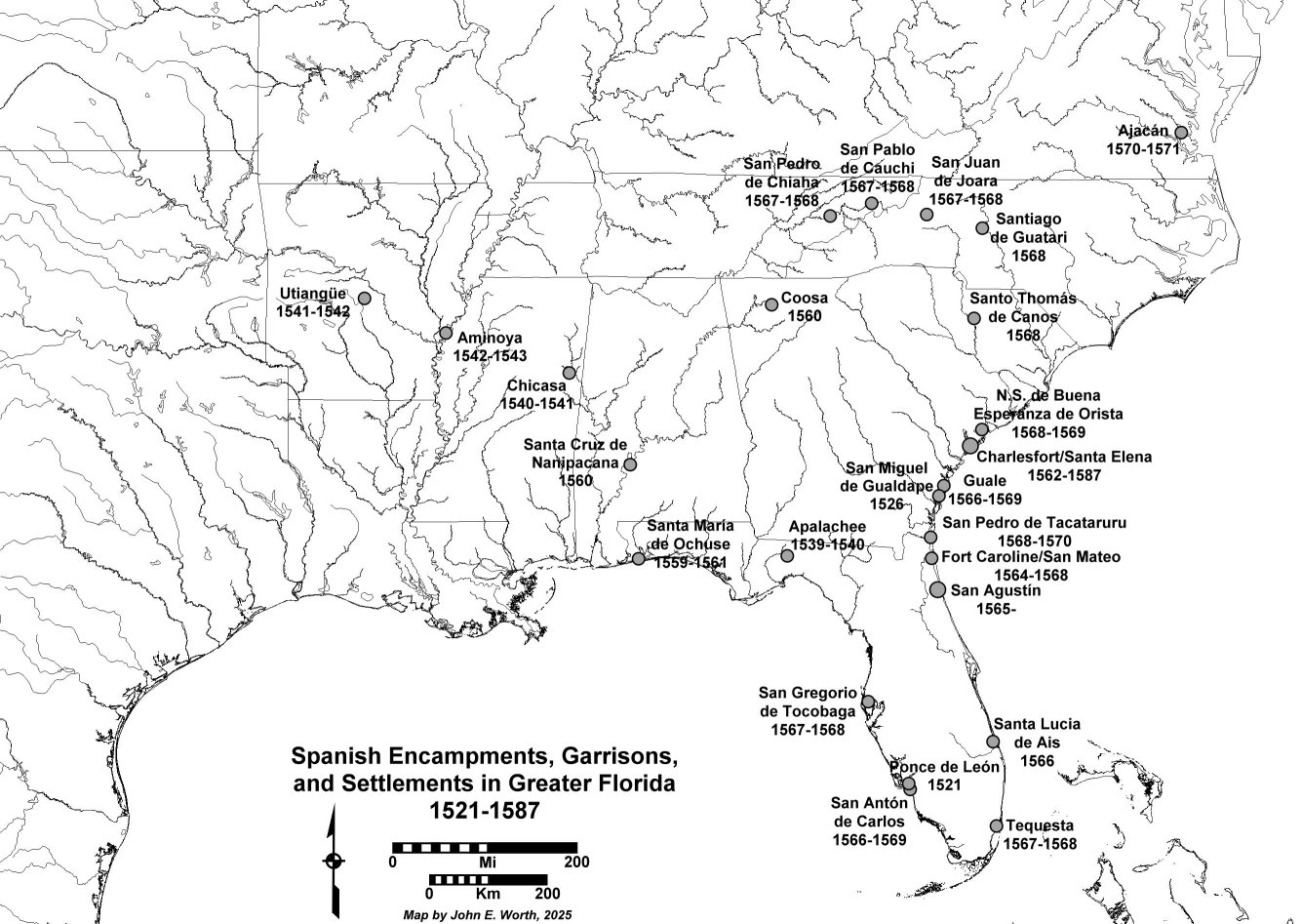
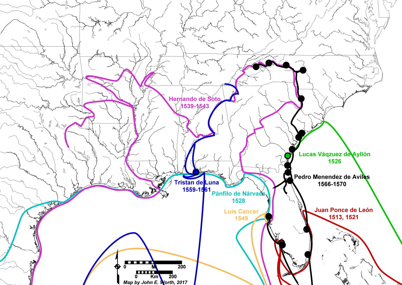
Spanish Florida, 1513-1570
The map below shows major Spanish expeditions and settlements both for the period prior to the 1565 establishment of St. Augustine, and for the first five years of military fortification under Pedro Menéndez de Avilés (see text descriptions here)
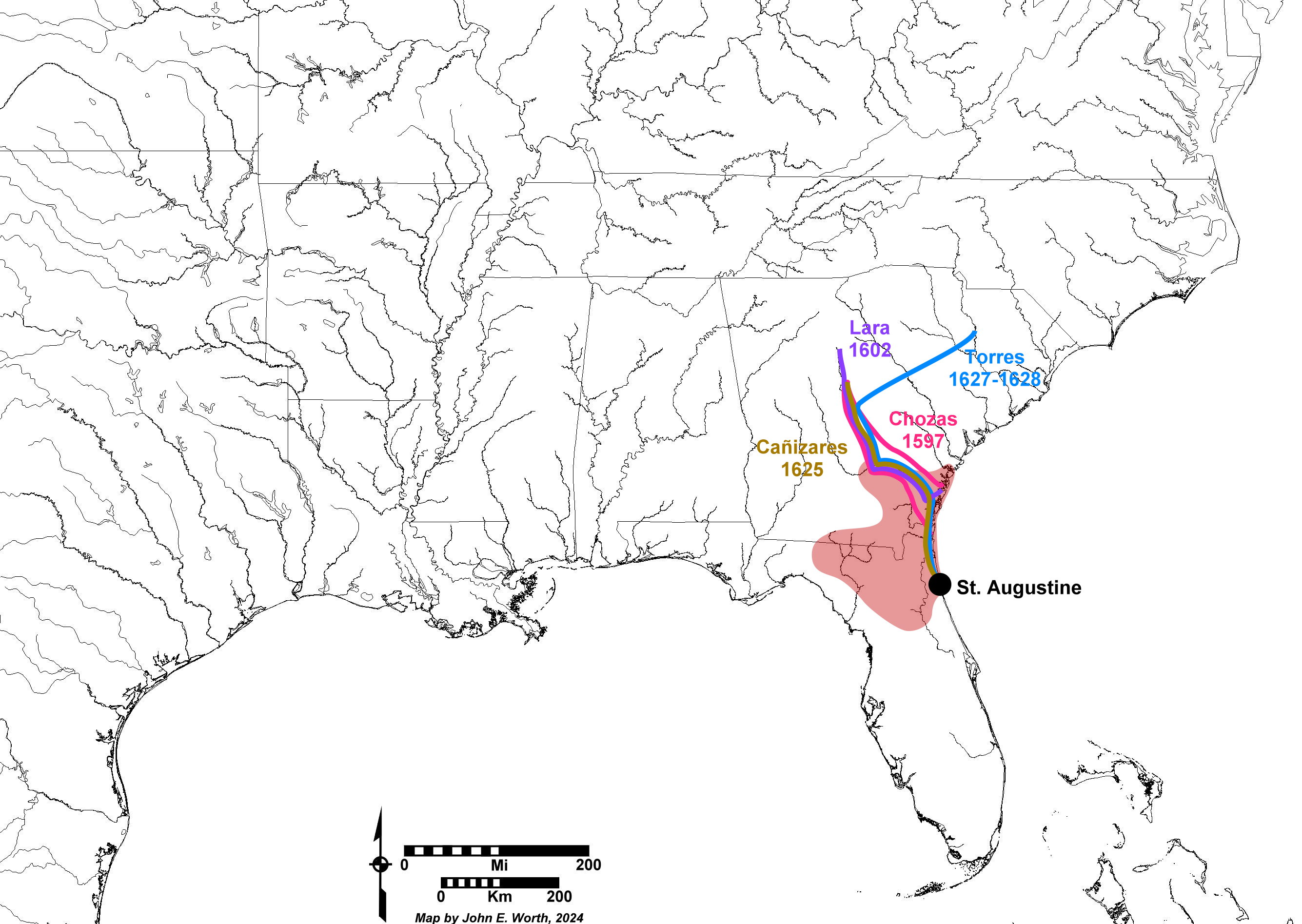
Late Military Expeditions in Spanish Florida, 1597-1628
The map below shows several late Spanish expeditions launched into the interior north of St. Augustine between 1597 and 1602, with missionized territory through 1633 in light red (see text descriptions here).
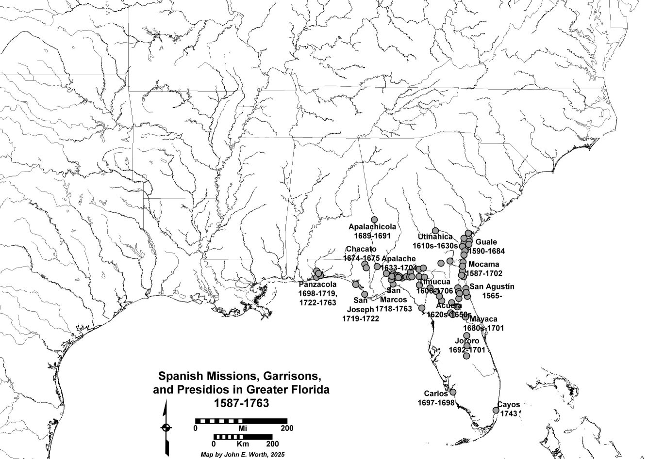
Spanish Florida, 1587-1706
The map below shows the maximum extent of Spanish Florida during the primary Franciscan mission period between 1587 and 1706, including the first of three presidios established in succession in Pensacola starting in 1698, and the short-lived Apalachicola fort.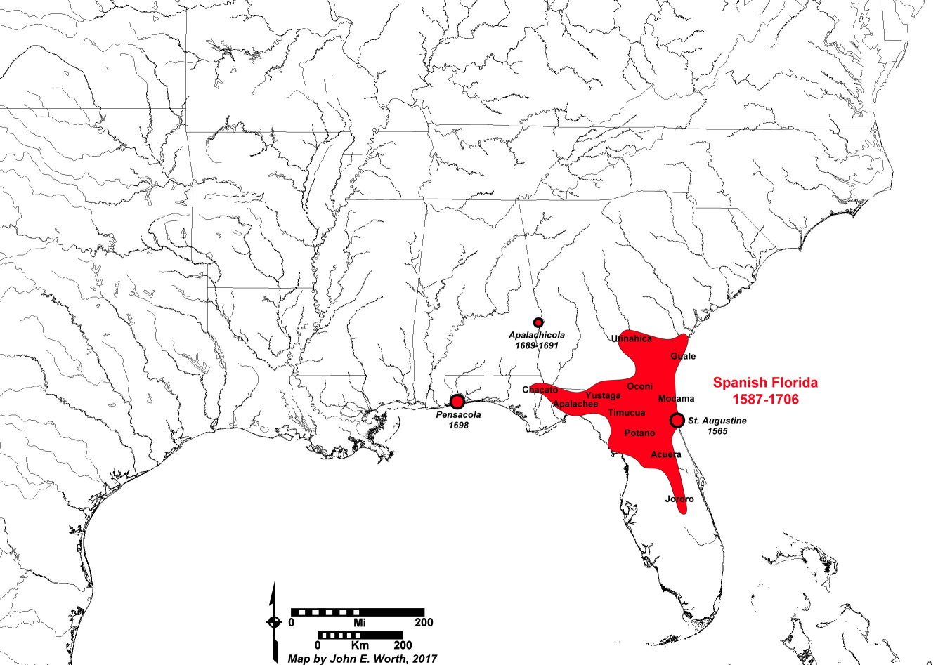
Spanish Florida, 1706-1763
The map below shows the locations of the surviving Spanish settlements after the collapse of the Franciscan mission system by 1706. In addition to the locations of presidios at St. Augustine and Pensacola (which included Presidio Santa Maria de Galve from 1698-1719, the brief relocation of this presidio eastward to St. Josephs Bay from 1719 to 1722, Presidio Isla de Santa Rosa from 1722 to 1756, and Presidio San Miguel de Panzacola from 1756 to 1763), the post-1718 Spanish fort at San Marcos de Apalache is also shown.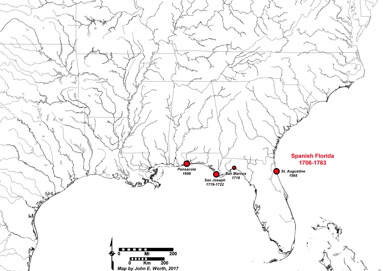
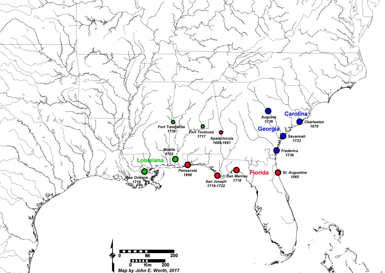
Spanish Florida Borderlands, 1670-1763
This map shows the locations of Spanish Florida's primary 18th-century presidios as well as neighboring settlements and fortifications by the English (in blue) and French (in green).