Missions of Spanish Florida
Back to: Places of Spanish Florida
See also: Presidios of Spanish Florida / Chronology of Spanish Florida
And see: Documents: Missions / Indigenous Groups of Spanish Florida
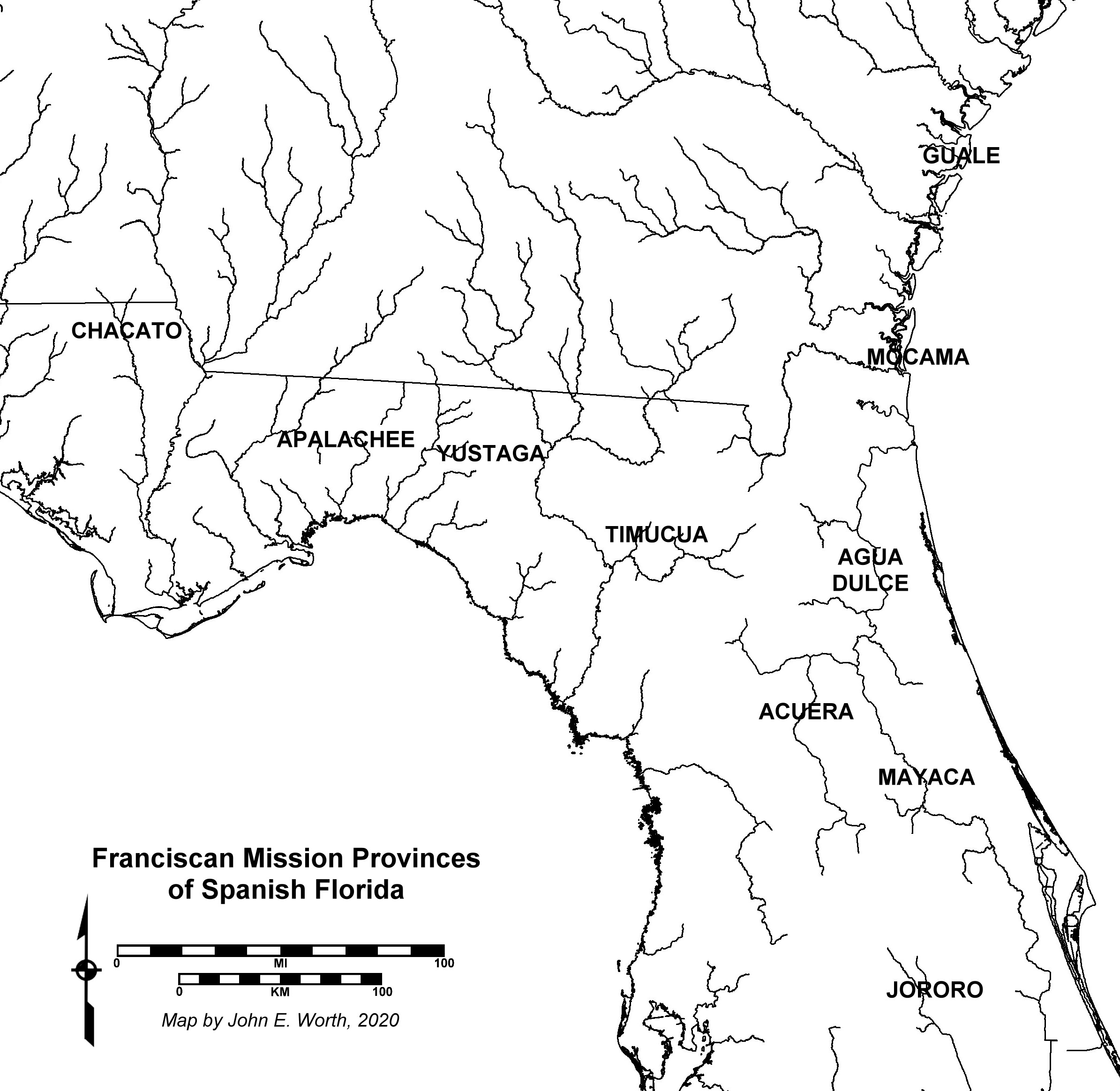 The mission provinces listed below (and shown on the map to the right) are dated to the period when Franciscan missionaries maintained active mission doctrinas with resident friars within indigenous communities in their original homelands. The terminal date of the province in all cases refers to the withdrawal of missionaries and in most cases the relocation of Christian natives into other provinces, or after the final collapse of the entire mission system between 1702 and 1706, their relocation to the refugee missions around St. Augustine and Pensacola. It should be noted that the largely pristine indigenous landscape of the 1560s had already been transformed as a result of early European exploratory and colonial activities by the time many of these provinces crystallized as described below.
The distilled lists of missions within each province below are derived from a wide range of sources, including a number of colonial-era mission lists, visitations, and censuses that have survived to the present day.
An excellent 1993 book on Florida mission archaeology and history available for 1-hour digital checkout online is below:
McEwan, Bonnie G.
1993 The Spanish Missions of La Florida. Gainesville: University Press of Florida.
North of St. Augustine
Mocama (1587-1702): Loosely integrated Timucua-speaking chiefdoms comprised of island and mainland communities extending along the intercoastal waterway from the mouth of the St. Johns River to St. Simons Island on the middle Georgia coast.
San Juan del Puerto (1587-1702)
San Pedro de Mocama (1587-1660s
Santa Maria (1587-ca. 1665)
San Buenaventura de Guadalquini (through 1684)
San Buenaventura de Guadalquini II/Santa Cruz y San Buenaventura de Guadalquini (1684-ca. 1696)
[interior west of Mocama]
Santiago de Ocone (ca. 1620s--1656)
San Lorenzo de Ibihica (ca. 1620s--1656)Guale (1590-1702): Comparatively well-integrated Guale-speaking chiefdom comprised of numerous island and mainland communities extending from the mouth of the Altamaha River to the mouth of the Ogeechee River.
San Diego de Satuache (1590s-1663)
San Phelipe de Alave (1590s- 1670)
San Phelipe II/ San Phelipe de Atuluteca (ca. 1670-1684)
San Phelipe III (1684-1702)
Santa Catalina de Guale (1590s-1680)
Santa Clara de Tupiqui (1590s-1674)
Santa Clara de Tupiqui III (1684-1702)
San Joseph de Sapala (1590s-1684)
Santo Domingo de Talaje (1590s-1661)
Santo Domingo de Asajo (1661-1684)
West of St. Augustine
Agua Dulce (1587-1706): A group of Timucua-speaking communities along the middle St. Johns River west of St. Augustine originally allied to chief Outina during the 1560s, that were collectively referred to as "Freshwater Timucua" during the 1590s (by then allied to Antonico), but which were severely depopulated by the early 17th century. Subsequent mission communities were relocated under Spanish direction from Timucua-speaking populations on the upper St. Johns and Oklawaha Rivers to maintain the river crossing on the camino real.
Tocoy (1587-ca. 1610s)
Antonico (1595-ca. 1615)
San Antonio de Enacape (1595-late 1650s?)
San Diego de Helaca (ca. 1624-27-ca. 1657-59)
San Diego de Salamototo (ca. 1657-1706)Timucua (1606-1706): Loosely integrated Timucua-speaking chiefdoms extending from the formerly-independent Potano region in the lake-district around and to the south and east of Gainesville, to the broad region defined by the Suwannee and Santa Fe Rivers.
San Francisco de Potano (1606--1705)
Santa Fé II, or Santo Thomás de Santa Fé (ca. 1657--1703)
Santa Fé de Teleco, or Santa Fé I (ca. 1609--ca. 1657)
San Martín de Ayacutu (1608--ca. late 1660s)
Santa Catalina (ca. late 1660s--1691)
San Agustín de Ajoica (ca. 1657--ca. 1675)
Santa Cruz de Tarihica I (ca. 1612--ca. 1657)
Santa Cruz de Tarihica II (ca. 1657--1691)
San Juan de Guacara I (ca. 1609--ca. 1657)
San Juan de Guacara II (ca. 1657--1691)
Santa Rosa de Ivitanayo (ca. 1682--1694)Yustaga (1623-1705): Loosely integrated Timucua-speaking chiefdoms occupying the interriverine region west and northwest of the Suwannee River (including several tributaries to the upper Suwannee), and extending to (and including) the Aucilla River to the west. See also early 19th-century American period GLO maps of this province here.
San Pedro I (ca. 1623--ca. 1691)
Santa Elena de Machava I (ca. 1620s--ca. 1691) / San Pedro II (ca. 1691--1704)
Santa Elena de Machava II (ca. 1691--1704)
San Matheo de Tolapatafi (ca. 1657--1704)
San Miguel de Asile (ca. 1620s--1704
San Agustín de Urihica, or Niahica (ca. 1620s?--ca. 1657)
Santa María de los Angeles de Arapaja (ca. 1620s--1657)
Santa Cruz de Cachipile (ca. 1620s--1657)
San Ildefonso de Chamile (ca. 1620s--1657)
San Francisco de Chuaquin (ca. 1620s--1657)Apalachee (1633-1704): Well-integrated and populous Apalachee-speaking complex chiefdom centered on the hilly high ground along the Cody Scarp around Tallahassee, including numerous scattered communities and farmsteads in the interriverine region between the Aucilla and Ochlockonee Rivers. See early 19th-century American period GLO maps of this province here.
San Lorenzo de Ivitachuco
Nuestra Señora de la Concepción de Ayubale
San Francisco de Oconi
San Juan de Aspalaga
San Joseph de Ocuya
San Pablo de Patale
San Antonio de Bacuqua
San Damián de Escambe/Cupayca
San Carlos de los Chacatos
San Luis de Talimali
San Pedro de Medellin de los Chines, Pacaras, y Amacanos
Nuestra Señora de la Candelaria de la Tama
San Martín de Tomole
Santa Cruz de Ychutafum/Capoli
La Asumpción del Puerto de los Chines, Pacaras, y Amacanos
Chacato (1674-1675): Cluster of Chacato-speaking communities in the karst region of the upper Chipola River.
San Carlos de Yatcatani (1674-1675)
San Nicolás de Tolentino (1674-1675)
San Antonio (1674-1675)
South and Southwest of St. Augustine
Acuera (c1610s-1650s): Cluster of Timucua-speaking communities along the Oklawaha River, eventually including the relocated Ocale community originally from the Withlacoochee River to the southwest.
San Blas de Avino (pre-1612--ca. 1620s)
San Luís de Eloquale (ca. 1620s?--late 1650s?)
Santa Lucia de Acuera (ca. 1620s--late 1650s?)Mayaca (1650s, 1690s): Cluster of nonagricultural communities situated along the upper St. J0hns River south of Lake George.
San Salvador de Mayaca (1650s, 1690s)
Jororo (1690s): Loosely integrated group of nonagricultural communities extending across the upper Kissimmee River watershed.
San Joseph de Jororo (ca. 1692-1697)
La Concepción de Atoyquime (ca. 1692-1697)
Atissimi (ca. 1696-1697)
South Florida
Though not strictly formal mission provinces like those above, there were sporadic mission attempts in South Florida that should nonetheless be mentioned. Many documentary translations relating to these missions are found in the book below:
Hann, John H.
1991 Missions to the Calusa. Gainesville, University of Florida Press.Carlos (1560s, 1590s): Powerful and geographically-extensive nonagricultural chiefdom centered at Mound Key in Estero Bay, but exerting dominance over much of Southwest Florida, including the western Florida Keys, Everglades, and the Okeechobee basin.
San Antón de Carlos (Jesuits 1567-1569) / Carlos (Franciscans 1598)
Tequesta (1560s, 1740s): Nonagricultural chiefdom centered at the mouth of the Miami River in Southeast Florida.
Tequesta (Jesuits 1567-1568) / Santa María de Loreto (Jesuits 1743)
Tocobaga (1560s):Nonagricultural chiefdom centered in Safety Harbor on the northern end of modern Tampa Bay.
San Gregorio de Tocobaga (Jesuits 1567-1568)