Mission San Antonio de Punta Rasa, ca. 1749-1761
Back to Pensacola Colonial Frontiers Project Page
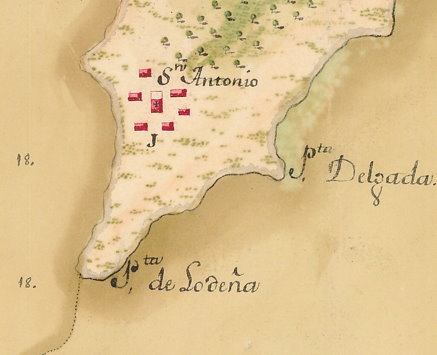 One of the original goals of the Pensacola Colonial Frontiers Project was to locate the archaeological sites of both of the Pensacola-area missions known to have been destroyed in the 1761 raids that destroyed Mission San Joseph de Escambe, which was successfully located during the UWF archaeological field school in 2a009 (for more details, see the 2009-2012 fieldschool blog, as well as online papers and reports for the project). As we approach our fifth field season at the Apalachee mission village of Escambe, attention is once again turning to the sister mission of San Antonio de Punta Rasa, inhabited by Yamasee Indians during the last 12 years of Escambe's existence along the Escambia River. Mission Punta Rasa was established about 1749 by immigrant Yamasee Indians who had previously settled about 1740 near Presidio Isla de Santa Rosa fleeing English General James Oglethorpe's siege on St. Augustine, where they had been living since 1715. Seeking greater autonomy and increased (though technically illicit) trade with the English-allied Creek Indians to the north and northeast, the immigrant Pensacola Yamasee moved across the bay to a location on the southern end of present-day Garcon Point, where they established a new village about 1749.
 During Punta Rasa's existence, Franciscan missionaries tended to the Catholic Yamasee in a mission church there, and a small detachment of four infantry soldiers were stationed there by the early 1750s. In 1757, the young Yamasee chief of Punta Rasa named Andrés Escudero was selected by the leaders of the Upper Creeks to be given the title of Governor General of the entire region, and he subsequently played a pivotal role in all high-level negotiations between the Creeks and the Spanish at Pensacola. At the end of 1759 he was also granted permission to open a public store in his house at Punta Rasa, where he was instructed to engage in fair trade with the Indians, avoiding abuses by individual Spaniards at Pensacola (and establishing a de facto monopoly on such trade through Governor Miguel Román). Among many other items, the Yamasee at Punta Rasa sold many of their own horses to the Spanish in order to supply the new cavalry garrison at Presidio San Miguel (at modern downtown Pensacola). In 1761, continued abuses of Creek Indian traders in San Miguel sparked the wholesale slaughter at Mission Punta Rasa on February 12 of the Spanish garrison leader Juan Gutierrez, his pregnant wife Rosalia Milán and a young daughter (a wounded nursing infant survived with wounds), along with two other soldiers. The mission was subsequently abandoned and destroyed by Creek Indian raiders who ravaged the Pensacola countryside during 1761. The surviving Yamasee inhabitants of Punta Rasa joined with the Apalachee refugees from Mission Escambe to form a short-lived town just outside Presidio San Miguel between 1761 and 1763, after which they all emigrated to Veracruz, Mexico upon the turnover of Spanish Florida to the British.
 After the departure of the Spanish and their Indian allies in 1763, British colonists began to distribute land grants in many favored locations alongside Pensacola Bay, including several along the western side of Garcon Point beginning in the spring of 1766. A British map published that same year (right) does not appear to include any of these soon-to-be granted plantation sites, but nonetheless shows a cleared field and a what seems to be an unlabeled settlement in just about the exact location shown on the 1756 Spanish map above. The plat map for one of the British grantees in that location also notes "corn land formerly cleared" and an "old fence" already in existence as of the 1766 survey, suggesting that they may well be associated with the Punta Rasa mission destroyed and abandoned in 1761. Regardless, the fact that this land grant and several other adjacent ones were clustered along the southwestern shore of Garcon Point makes it likely that this land was chosen because of the same types of qualities that led to the original settlement of the Yamasee in this location during the 1740s.
Based on documentary clues, traces of Mission San Antonio were finally located as a result of archaeological survey carried out in 2016 with UWF student assistance under Dr. Patrick Johnson as part of his dissertation research at the College of William and Mary. While the archaeological site seems to have experienced considerable disturbance, in part due to its location so close to sea level, future research may add to our knowledge of this important site.