 |
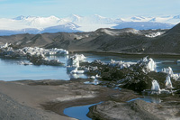
1. Bratina Island. January 2000. McMurdo Ice Shelf, Antarctica. This is not an island at all, but rather an extensive series of ponds created in sand and rocks pushed on top of the McMurdo Ice Shelf by shifting ice. Due to the dark color of the sand, it warms and melts into the underlying ice creating ponds. There are thousands of ponds at Bratina Island, and although they are very close together, they are very different in both their chemistry (from freshwater to hypersaline) and the microbes that thrive in those ponds. |
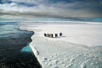 |
2. Penguins on the Edge. November 2005. Ross Sea, Antarctica. A small group of Emperor penguins wait on the edge of the sea ice. The ship had followed a channel into thicker ice to await a delivery from a helicopter. Penguins are naturally curious of anything on the ice and swarmed the ship for the two days it was parked in the ice. Sea ice plays a critical role in the ecology of the Southern Ocean, serving as substrate for algae that in turn serve as a food source for krill, a primary food for penguins. Loss of sea ice has resulted in lower krill density and changes in penguin populations. |
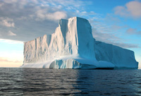 |
3. Iceberg #1. November 2005. Ross Sea, Antarctica. Icebergs play a significant role in the microbial ecology of the Southern Ocean, mixing fresh water with seawater, and changing nutrient availability that can lead to stimulation of planktonic growth. Scientists hypothesize that the melting icebergs stimulate phytoplankton growth and remove more carbon dioxide from the oceans and perhaps buffer climate change. |
|
4. Sea ice #1. November 2005. Ross Sea, Antarctica. Patterns in young sea ice often referred to as “pancake ice” are formed as small areas of the sea freeze, and then due to wind and wave action, bang into each other resulting in the rounded shapes. Temperatures drop enough that the pancakes freeze together. Snow accumulation around the edges magnifies the appearance of the edges. The diagonal lines crossing the image are penguin tracks from group scooting on the ice surface. |
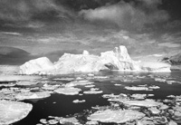 |
5. Iceberg #2. November 1998. Gerlache Straight, Antarctica. The eroded arch and irregular edges testify to the age and weathering of this iceberg. Wind and wave action wear away at the edges and faces of the icebergs resulting in amazing shapes and patterns. Like snowflakes, no two icebergs are alike. |
|
6. Sea Ice #2. November 2005. Ross Sea, Antarctica. A close up view of broken, tumbling ice churned by the research vessel while it cut a channel to the next sampling site. |
|
|
7. Hutton Cliffs. October 1981. Ross Island, Antarctica. This is from my first day of field work during my first trip to Antarctica over thirty years ago. I helped tag seal pups with scientists from the University of Minnesota. The cornice hung over the edge of the sea ice where the seals crawled onto the ice through cracks and holes. The shapes, size, and beauty of ice formations struck me from that first day. |
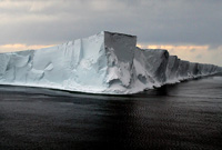 |
8. Ross Ice Shelf. November 2005. Ross Sea, Antarctica. The largest ice shelf in Antarctica is approximately the size of France. The shear face of the shelf as it empties to the sea is 50 – 150 feet high. Like all floating ice, however, ninety percent remains under water. The Ross Sea was considered the last ocean not significantly impacted by human activities, although new research has documented significant changes. |
|
9. Geyser del Tatio #1. May 2013. El Tatio, Northern Chile. Located at approximately 14,000 feet (4300 m) elevation in the Andes Mountains, El Tatio has approximately eighty geysers making it the largest geyser field in the southern hemisphere and the third largest in the world. It is a popular tourist destination at sunrise when the steam clouds from the individual geysers are at their peak. There was a failed attempt to harness geothermal power from the geyser field from 2008-2009. The chemistry associated with the geysers and their ponds as well as organic material from plants and animals (vicuña, similar to alpacas) provide variable environments supporting diverse microbial communities. |
|
10. Huasco Salt Pond. November 2013. Salar de Huasco, Chile. The elevation is over 12,000 feet (3660 m) in a region known as the Chilean altiplano. The salinity in the water is about eight times saltier than seawater. The water in the salar recently receded leaving just a few small ponds in this part of the salt plain. The very high solar intensity and evaporation result in very high salt content in these ponds. The white surrounding the pond is salt. The orange color indicates microbial communities and the footprints leading to the pond are most likely from a llama. |
|
11. Llamará Salt Pond. May 2013. Salar de Llamará, Atacama Desert, Chile. These very old, round salt crystal structures exist in the Llamará lagoon in the Atacama Desert. The shallow ponds in the middle of a salt plain result in very high salinities, up to eight times saltier than seawater. Salt content is either halite (sodium chloride) or gypsum (calcium sulfate). Solar intensity is very high, yet the biology is quite complex including bacteria, archaea, plants and brine shrimp. The microbial communities are quite extensive and diverse, adapting to the extremes in light and salt. |
|
|
12. Lirima Hot Spring. November 2013. Lirima, Chile. The elevation is over 12,000 feet (3660 m) and the clear water temperature is approximately 160° F (70° C), but smells of sulfide. The bright red ring around the outer edge of the pond is made up of microbes. There are a series of thermal springs and ponds in this area, but only one is recommended for bathing as its temperature is approximately 100° F (38° C). The others are much hotter between 120 - 160° F (50 – 70° C). There have been attempts here to harness the geothermal activity but it is now a good example of a threatened natural resource as private water rights are now claimed for commercial purposes. |
|
|
13. Geyser del Tatio #2. May 2013. El Tatio, Northern Chile. The largest hot spring in the El Tatio geyser fields in northern Chile. The water temperature was over 165° F (75° C). As the water cools and becomes shallow, a very dense cyanobacterial red mat forms along the perimeter of the deeper spring. |
|
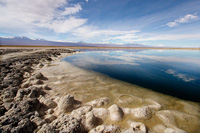
14. Huasco #1. November 2013. Salar de Huasco, Chile. These shallow waters of the spring fed lagoon support a more extensive plant community than other areas in the desert and altiplano. This, in turn, supports a large animal community including llamas, sheep, alpaca, and several species of birds. Footprints can be seen as they forage through the lagoon. |
 |
15. Cejar Sinkhole #1. May 2013. Laguna de Cejar, Atacama Desert, Chile. Fed by ground water springs from the Andes Mountains, these ponds also have very high salinities. The lagoon is a part of Los Flamencos National Reserve, a 740 square kilometer preserve near San Pedro de Atacama in Northern Chile. The presence of birds, plants and other wildlife make this a more productive and richly populated habitat compared to the isolated ponds of the Lagoon de Llamará. |
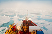 |
16. Shot Across the Bow. August 2009. Beaufort Sea, Arctic Ocean. The encompassing view from atop the bridge deck of the Canadian Coast Guard Ice Breaker CCGS AMUNDSEN soon after sunrise gives a reminder of the other-worldliness of the landscape. The ship got stuck in the ice for a brief period that morning and had to “back and ram” its way into more open water. |
 |
17. Arctic Sea Ice. August 2009. Beaufort Sea, Arctic Ocean. Weathered ice from the polar ice cap melts into lacy patterns as it moves south. It then started to refreeze and was a constant reminder that climate change was breaking up ice and moving it into areas where it was not usually found. |
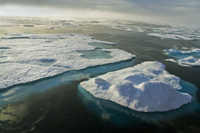 |
18. Blue Ice. August 2009. Beaufort Sea, Arctic Ocean. Bright sunlight and clear waters bring out the blue color in the sea ice in the Arctic Ocean. A closer look shows the weathering patterns along the edges of the pieces of ice indicating its age. The proposed project had planned to work in open water but we regularly had to deal with heavy ice that thwarted or slowed our ability to work. The presence of this brilliant blue ice was not encouraging because it indicated that ice from the polar cap was breaking up and drifting south to where we needed to work. |
|
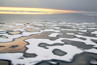
19. Fire and Ice. August 2009. Beaufort Sea, Arctic Ocean. Clouds hampered visibility for several days, but when the sun finally came out it made for a dramatic sunset. Ice formations in the Arctic were very different than the Antarctic, most of the ice was young (annual ice) that had broken off the polar cap and drifted southward to where we were working in the Beaufort Sea. |